WD 10.37S81 on Win 7 SP1 64bit - I entered the correct Lat Long from the NWS point forecast page [29.7532 95.3980] and I entered the correct USA TX ZONE [TXZ213]. The file TXZ213.txt is being downloaded correctly, and when opened in notepad it shows the correct forecast [TXZ213-232100-Inland Harris-Including the city of Houston], but when I check Show on main screen scroll text and then click the view button - a window pops up titled “Forecast” but it shows the forecast for 2 miles SSE Prairie Village, KS [roughly 39 94.6 lat long].
What have I done wrong? :oops: How can I fix this?
I am still in the process of slowly bringing this Weatherflow station setup with Weather Display all together. I was a very long time user of VWS in the past, but it seems as with all things one must evolve of face extinction!
the last time I tested the point forecast it worked OK, but they have probably made changes since then
(you can instead use the default way (I have a youtube video showing how to do that)
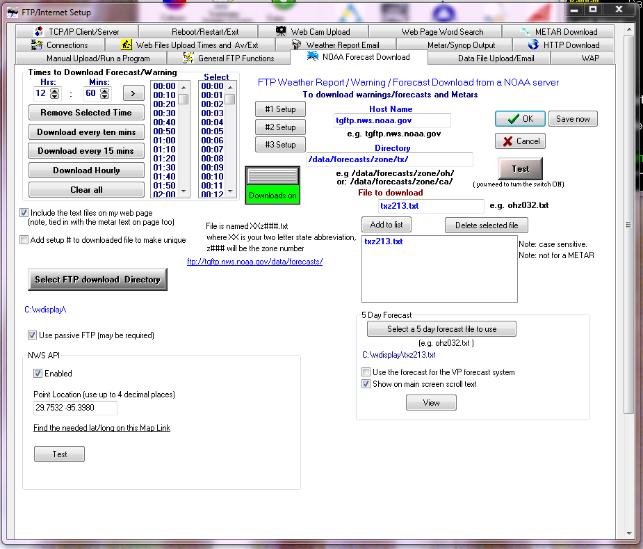
post a screen shot of how you have setup and I will test/check here (as spare time permits…I am currently in the process of potting up 1000’s of native trees)
I have tested by setting to download the txz213.txt file
and then selected that file to use as the 5 day forecast
and then when I click on view, that 5 day forecast shows up correctly and looking OK
have you done that?
(and then also tick to use for VP forecast system and then in the summary image and icon setup, set to show the VP forecast ticker)
that is working here in testing
I will test using the new NWS API point forecast next
I keep learning new things. Following your instructions here, i too am downloading the correct text file. (gaz007.txt) added it to five day view and also get prairie village kansas when i click view and from the main wd screen.
A little more info. I found that while the download txt file would work with ‘test’, it was not downloading on the schedule. That was because the download list is cumulative with other (http) downloads. I have a radar map in http downloads in slot 1 and a solar conditions (ham radio) forecast in http slot 2. When i move the noaa text to slot 3, it downloads on schedule.
Pointing the 5 day forecast to the downloaded file is correct, yet i am still in Prairie Village, KS. That’s really weird. Its not just the label, but actually is the forecast for Prairie Village. Where is it getting that data? The downloaded gaz006.txt has my correct forecast data.
Ah ha! If i turn off NWS API with lat long, it shows the correct data. I have the correct data in lat/long, so the question is ‘what is the correct format for lat/long?’
Are the lat and long separated by a comma? is the long a negative number for west of 0?
the NWS api I did have working when the info was first made available about that
but there has probably been a few changes
I need to retest, when I get a chance