New thread with subject line.
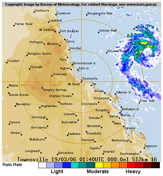
currently Cat 3 965 hpa
Brian is in Brisbane, trying to organise a flight for him up here, can’t get through on his phone
New thread with subject line.
currently Cat 3 965 hpa
Brian is in Brisbane, trying to organise a flight for him up here, can’t get through on his phone
IDQP0005 Australian Government Bureau of Meteorology Queensland Tropical Cyclone Warning CentreMedia: For Broadcast within the hour. The Standard Emergency Warning Signal
should NOT be used with this warning.TOP PRIORITY
TROPICAL CYCLONE ADVICE NUMBER 8
Issued by the Bureau of Meteorology, Brisbane
Issued at 7:43am on Sunday the 19th of March 2006A Tropical Cyclone WARNING is now current for coastal and island communities
from Cape Flattery to Mackay and extending to inland areas about Chillagoe and
Charters Towers.At 7 am AEST Sunday, Severe Tropical Cyclone Larry, category 3 with central
pressure 965 hectopascals, was centred in the Coral Sea near latitude 17.6 south
and longitude 152.1 east, about 680 km east of Cairns. The cyclone is expected
to intensify further, and move in a general westerly direction at about 25 km/h
over the next 24 hours. The centre of Tropical Cyclone Larry is likely to be
near the Queensland coast early Monday morning.Damaging winds with gusts to 120 km/h are expected to develop about the
Whitsunday Islands late this afternoon, and extend to the coast between Cape
Flattery and Mackay overnight Sunday.Very destructive winds, with gusts to 230 km/h, may develop on the coast between
Cape Tribulation and Bowen on Monday morning.As the centre approaches the coast, sea levels are likely to rise well above the
normal tide, with damaging waves and flooding of some low-lying areas near the
shoreline.Heavy to flood rains are likely to develop near the coast between Cairns and
Mackay during Sunday night.Details of Severe Tropical Cyclone Larry, Category 3, for 7 am AEST Sunday
Central Pressure : 965 Hectopascals
Location of Centre : within 40 kilometres of
latitude 17.6 degrees south
longitude 152.1 degrees east
about 680 kilometres east of Cairns
Recent Movement : West-southwest at 25 kilometres per hour
Destructive winds : out to 80 kilometres from the centre
Maximum wind gusts : 180 kilometres per hour, intensifyingPeople between Cape Flattery and Mackay should continue preparations, and in
particular secure boats and property.The next advice will be issued at 11am AEST Sunday.
Hi Cyclone ![]()
the strongest TC in 20 years I heard?
try textting to that cell number…that will work…(the phone number would need some extra numbers at the start, as its a NZ number)
texting works, as we have been texting back and forth to NZ ![]()
wow, a fligth up to cairns…into a CAT3 TC due tomorrow…
but will I be able to get back to Brisbane the next day?
the wife will kill me if i abandon her with the fam damily…on our family hoiday!!!
but its very tempting, chance of a life time!
Looks like more low pressures forming behind that cyclone larry, as i saw on:http://www.weatherzone.com.au/charts/ecmwfMSLPressure.jsp but you have to click hours after hours on top bar there.
Very nice looking Larry there, The Price is Right!! LOL
Matt
Media: For immediate broadcast. Transmitters in the area Cape Flattery to Mackay are requested to use the Standard Emergency Warning Signal.TOP PRIORITY
TROPICAL CYCLONE ADVICE NUMBER 9
Issued by the Bureau of Meteorology, Brisbane
Issued at 11:04am on Sunday the 19th of March 2006A Tropical Cyclone WARNING is now current for coastal and island communities
from Cape Flattery to Mackay, and extending to inland areas about Georgetown,
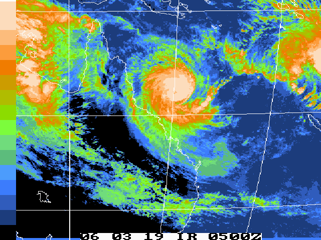
Greenvale and Charters Towers.At 10 am AEST Sunday, Severe Tropical Cyclone Larry, category 4 with central
pressure 950 hectopascals, was centred in the Coral Sea near latitude 17.7 south
and longitude 151.2 east, about 550 km east of Cardwell and 600 km east of
Cairns. The cyclone is expected to intensify further, and move in a general
westerly direction at about 25 to 30 km/h over the next 24 hours. The centre of
Severe Tropical Cyclone Larry is likely to be near the Queensland coast early
Monday morning.Damaging winds with gusts to 120 km/h are expected to develop about the
Whitsunday Islands late this afternoon, and extend to the coast between Cape
Flattery and Mackay tonight.Very destructive winds may develop on the coast between Cape Tribulation and
Bowen on Monday morning, with maximum wind gusts reaching 280 km/h near the
centre of the cyclone.Coastal residents between Cairns and Townsville are specifically warned of the
dangerous storm tide as the cyclone crosses the coast. The sea is likely to
steadily rise up to a level which will be significantly above the normal tide,
with damaging waves, strong currents and flooding of low-lying areas extending
some way inland. People living in areas likely to be affected by this flooding
should take measures to protect their property as much as possible, and be
prepared to follow instructions regarding evacuation of the area if advised to
do so by the authorities.Heavy to flood rains are likely to develop near the coast between Cairns and
Mackay during Sunday night.Details of Severe Tropical Cyclone Larry, Category 4, for 10 am AEST Sunday
Central Pressure : 950 Hectopascals
Location of Centre : within 40 kilometres of
latitude 17.7 degrees south
longitude 151.2 degrees east
about 550 kilometres east of Cardwell
Recent Movement : West at 30 kilometres per hour
Destructive winds : out to 120 kilometres from the centre
Maximum wind gusts : 230 kilometres per hour, intensifyingPeople between Cape Flattery and Mackay should complete preparations before
nightfall, especially securing boats and property.
The next advice will be issued at 2 pm AEST Sunday.
Thats a big one Becareful There
Coyote
I hear they’re already closed down the Townsville airport in preparation for things.
Got friends in Bowen who have got everything tied down, although they say they’ve been told to watch out for the tail of it, but apparently it isn’t quite as bad as BOM has forecast it as.
Edit: quite as bad… according to what the locals up there reckon, but with it possibly growing up to a category 5, I think they’re talking thru their bums. ![]()
Evening Brian! Category FIVE expected 8O 8O 8O 8O 8O
And I believe all airports are being shut up there.
Back home, easterlies set to bring heavy showers shortly ![]()
Hi
I decided not to chase this one!
and watch from a safe distance
Talked to Cyclone by phone a few times during the day, and we decided that I might end up stranded in Cairns for a few days
and it was not going to be much fun on my own with no weather instruments, no laptap, etc etc!!
I hope you dont get hit too hard Cyclone (being inland will help).
The eye shows up nicely now on sat images!
seems to be tracking slightly more Nth now?
why does ECMWF have in become stationary? …or is that the next one???
Brian
Cat 4, very close to Cat 5
Brain, i think they closed the airport !!!
www.gorgecreekorchards.com.au
yes, i think a Cat 4/5 TC is not one to chase, but one to avoid!!! 8O 8O
would have been one heck of an experience though!!
Good luck everyone up there…from a safe distance here in Brisbane area!!!
so even if i tried to get on the 5pm flight they might have cancelled it?
i will try making contact with you tomorrow Cyclone!
Just 10 hours away now.
Australian Government Bureau of Meteorology Queensland Tropical Cyclone Warning CentreMedia: For immediate broadcast. Transmitters in the area Cape Tribulation to
Mackay are requested to use the Standard Emergency Warning Signal.TOP PRIORITY
TROPICAL CYCLONE ADVICE NUMBER 15
Issued by the Bureau of Meteorology, Brisbane
Issued at 10:56pm on Sunday the 19th of March 2006A Tropical Cyclone WARNING is now current for coastal and island communities
from Cape Tribulation to Mackay, and extending to inland to near Normanton.A Tropical Cyclone Watch has now been extended onto the southeast coast of the
Gulf of Carpentaria.Severe Tropical Cyclone Larry poses a VERY SERIOUS THREAT to life and property
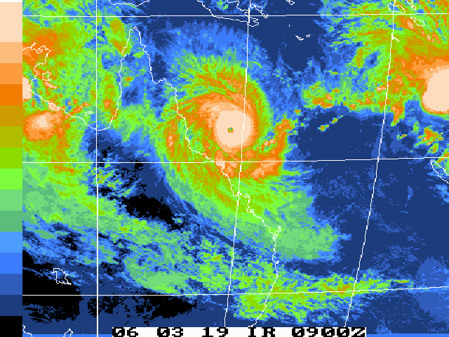
in the warning area.At 10 pm AEST Sunday, Severe Tropical Cyclone Larry, Category 4 with central
pressure 925 hectopascals, was centred in the Coral Sea near latitude 17.5 south
and longitude 148.3 east, about 240 km east of Innisfail. The cyclone is
expected to continue to move in a general westerly direction TOWARDS THE COAST
at about 25 km/h.The VERY DESTRUCTIVE CORE of SEVERE TROPICAL CYCLONE LARRY with EXTREME GUSTS of
approximately 280 km/hr should cross the coast between INNISFAIL and MISSION
BEACH between 7am and 9am MONDAY MORNING. DESTRUCTIVE winds are expected to
commence along the coast between INGHAM and PORT DOUGLAS early MONDAY MORNING.
GALES are already being experienced along the exposed coast in the warning area.Coastal residents between Cairns and Townsville are specifically warned of the
dangerous storm tide as the cyclone crosses the coast. The sea is likely to
steadily rise up to a level which will be significantly above the normal tide,
with damaging waves, strong currents and flooding of low-lying areas extending
some way inland. People living in areas should be prepared to evacuate if
advised by authorities.A preliminary flood warning has been issued for coastal rivers and streams
between Innisfail and Mackay.Details of Severe Tropical Cyclone Larry, Category 4, for 10 pm AEST Sunday
Central Pressure : 925 Hectopascals
Location of Centre : within 20 kilometres of
latitude 17.5 degrees south
longitude 148.3 degrees east
about 240 kilometres east of Innisfail
Recent Movement : West at 25 kilometres per hour
Destructive winds : out to 120 kilometres from the centre
Maximum wind gusts : 280 kilometres per hourPeople in the path of this VERY DANGEROUS CYCLONE should stay calm and remain in
a secure shelter - above the expected water level - while the very destructivewinds continue. Do not venture outside if you find yourself in the eye of the
cyclone - very destructive winds from a different direction could resume at any
time. Follow the evacuation advice or directions of Police or State Emergency
Service personnel.People over inland areas around Normanton and the southeast Gulf of Carpentaria
should consider what action they will need to take if the cyclone threat
increases.The next warning will be issued at 12 pm AEST Sunday.
As of about 9:30 pm jets where still landing and taking off in Townsville.
I think the media needs to get their stories straight. The airport was not closed earlier today, but what did happen is the RAAF flew all it’s FA18’s out. That is normal procedure. You don’t want a multi-million dollar aircraft tossed on it’s back on the tarmack.
At present time, just passed midnight, it’s fairly quiet here at the moment. Barometer is dropping at about -0.9hPa/hr. reading 1008.2, 6.2mm rain so far today, max wind speed 29.0K/ph.
Outside there is only light intermittent rain and it’s a bit windy. Apart from that all is well.
And now Wati. 8O
Tropical Disturbance Advisory Number A3 issued from RSMC NADI Mar 19/1408 UTC 2006 UTC.Tropical Cyclone Wati centre [995hPa] was located near 15.9 South
163.2 East at 191200 UTC. Position poor based on MTSAT EIR imagery
with animation. Cyclone moving west-southwest 13 knots. Maximum
10-minute average winds near the centre estimated at 35 knots
increasing to 45 knots in the next 12 hours. Expect winds over 33
knots within 90 miles of centre in the sectors from northwest through
north to east and within 60 miles of centre elsewhere.LLCC now underneath the developing CDO. Overall organisation steadily
improving. Deep convection about central area steadily increased and
cooled past 12 hours. Outflow good to north but still restricted
elsewhere. Dvorak analysis based on log10 spiral wrap of .6, yielding
DT=3.0. MET and PT agree at 3.0. Thus, T3.0/3.0/D1.0/24hrs. Wati lies
just to the north of the 250 hPa ridge axis. Vertical wind shear
around 15 to 25 knots but anticipated to decrease gradually. SST
around 29 to 30C. Cyclone is beeing steered west-southwest by a deep
mean northeast flow driven by a mid-level sub-tropical ridge to the
south. Consensus of available global models agree on steady
west-southwest track with slight, further intensification.FORECAST:
12hrs valid at 200000 UTC near 16.7S 160.7E mov WSW 13kt with 45kt
close to centre.
24hrs valid at 201200 UTC near 17.9S 158.0E mov WSW 13kt with 50kt
close to centre.OUTLOOK:
36hrs valid at 210000 UTC near 18.8S 156.0E mov WSW 12kt with 60kt
close to centre.
48hrs valid at 211200 UTC near 19.0S 154.1E mov WSW 12kt with 65kt
close to centre.The next Tropical Disturbance Advisory on TC Wati will be issued
around 192000UTC.
Hi
I see Cyclone is getting hit now (inland from Cairns)
with 40 knots winds
wtiht eh barometer dropping fast
TC Larry should have crossed over the coastline now
places just to the north of it, with the westerly wind, I would say, would get very strong dumping type gusts off the great dividing range there just inland? (450m)?
Brian
hey, foggy, whats the chances the 2nd cyclone might curve to get NZ?
Thanks for the update, I was a little bit unsure when I passed that bit of mis-information along… seemed to have been an awful long time to close down the airport before a cyclone.
You’re not wrong, I’d want all those FA18’s well clear of a cyclone, they’re a little bit too pricey to have them sitting on their backs. ![]()
Our barometer is currently rising, reading 1018.1 , but then again we’re still an awful long way away from it down here south of Brisbane. ![]()
Hi
Brian here at WeatherOz’s headquarters, here in Queensland!!!
Nice rural area, heaps of room to swing a cat!
![]()
Hi Weatheroz and Brian,
Its gone ominously quiet … apart from what we’re hearing on the news.
Have u heard from cyclone? His staion was offline from mid-morning (our time here in NZ).
How about a summary of things there from a local viewpoint? err that should be a local local viewpoint and a kiwi local viewpoint?? #-o
Ooops. I saw the note on Cyclone’s weather page about the damaged weather station, but didn’t follow the link to his alternative “live” page. Not sure whether the reading of 106 kmh was before he lost the anemometer or after …
Still, you guys have access to local news sources in Oz. What’s happenin’ around the Cape York Pen.?