24 hpa = 0.7" inHg 8O
we do get lows (explosive cyclogenesis) deepen that fast every few years
we had one just recently ![]()
you need a good jet stream
and then then a tropical air mass meeting a polar airmass (australia helps to set that up, one air mass gets deflected and the other airmass has to go up and under and around sort of thing, to meet in the tasman sea ![]()
The NWS predicted it but I haven’t seen any confirmation that there was that big a drop during this recent cycle. Anyway looks the south is off the hook for the moment and northern cal will be getting the next one.
Meanwhile at the Oroville dam most of the water has given up on the main spillway and is forging a new path.
Also in the LA Times today some interesting insight into how we got into this mess.
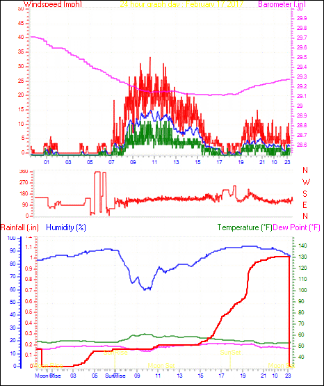
Checking my weather history, I guess I found some evidence of it here. Starting on Feb 16 the max pressure was 29.94 in. the pressure continued dropping thru Feb 17 bottoming out at 29.11 in. with a difference of .83 in. The corresponding graphs for Feb 16 and Feb 17 are attached.
Feb 16
Maximum pressure 29.942 in. on day 16 at time 11:01
Minimum pressure 29.710 in. on day 16 at time 23:46
Feb 17
Maximum pressure 29.714 in. on day 17 at time 00:02
Minimum pressure 29.112 in. on day 17 at time 17:31

It’s been windy in the mountains 8O
[quote]On Tuesday, dramatic gusts were recorded by sensors in the Lake Tahoe Basin, where Ward Peak had a 199-mph gust, according to the weather service. Sierra Crest recorded 193 mph, and Biggs had 184 mph.
Not too far from me.
Photos: Severe flooding forces hundreds of water rescues around San Jose, California
http://www.accuweather.com/en/weather-news/photos-severe-flooding-forces-hundreds-of-water-rescues-around-san-jose-california/70000918
Interesting read.
Every 200 years California suffers a storm of biblical proportions
Interesting indeed. That Len Ramirez spillway picture should be in the dictionary under the definition of clickbait :roll:
Yeah, you’re right. I thought it looked rather odd. Of course, I don’t know that area.
Geeez, more flooding concerns. I was just wondering how the levees were holding up.
[size=83]Event: Flash Flood Watch Alert: ...FLASH FLOOD WATCH REMAINS IN EFFECT THROUGH SATURDAY MORNING... The Flash Flood Watch continues for
A portion of northern California…including the following area…Carquinez Strait and Delta.
Through Saturday morning
River levels in the delta continue to be elevated due to in
coming flood flows and reservoir releases from upstream rivers.
The flood flows from Don Pedro Reservior are expected to be
arriving in the south Delta Wednesday evening.Previously identified concern areas on local levees will see
increased river levels over the next week. As a precaution,
San Joaquin County officials and the National Weather Service
are encouraging local residents to be prepared to take action
in the event that levee conditions were to deteriorate.
[/size]
[size=83]Event: Flash Flood Watch Alert: ...FLASH FLOOD WATCH IN EFFECT THROUGH SATURDAY MORNING FOR THE LEVEES ALONG THE LOWER SAN JOAQUIN RIVER AND IN THE DELTA OF NORTHWESTERN STANISLAUS AND SOUTHERN SAN JOAUQIN COUNTIES... The National Weather Service in Sacramento has expanded the
Flash Flood Watch to include a portion of northern
California…including the following area…Northern San
Joaquin Valley.Through Saturday morning
Don Pedro and other local dams are making large reservoir
releases that are raising river levels along the Lower San
Joaquin River north of Grayson. These elevated levels are
causing flooding in the low lying bottom areas along the river
and increasing concerns on the levees of the area.[/size]
From what I see on google earth, the spillway is about 1/2 mile from the closest house, not in someone’s backyard.
I thought 1/2 mile is classed as someones back yard in US terms :lol: :lol: over here its meters lol everything over there
is so much bigger…
Due to the price of land and demand for housing (silicon valley) that area has been invaded by large homes crammed on small lots.
AH, fair point… :roll:
Video of the Oroville dam spillway with the water flow shut down 8O (Official video from CA Water Resources.)
Found Part 2 here.
We can see now how it was put together, definitely no rebar, just a bunch slabs put together and they thought that would take care of it. I heard a price tag of $700 million just to rebuild it.
Yeah, pitiful, even driveways have rebar :roll: The amount of rubble in the river in the second video is impressive, it’s no wonder they can’t run the power plant with all that blocking the outflow.
WOW, that won’t get fixed in a week! 8O :?
I like this pic, gives some perspective on the sheer size involved…

That is a good one ![]()
I like this one from the Sacramento Bee too, shows just how much crap they have to move to open up the power plant outflow again: