you put the extra text in the email setup in the wdxmlwarning program (as posted above)
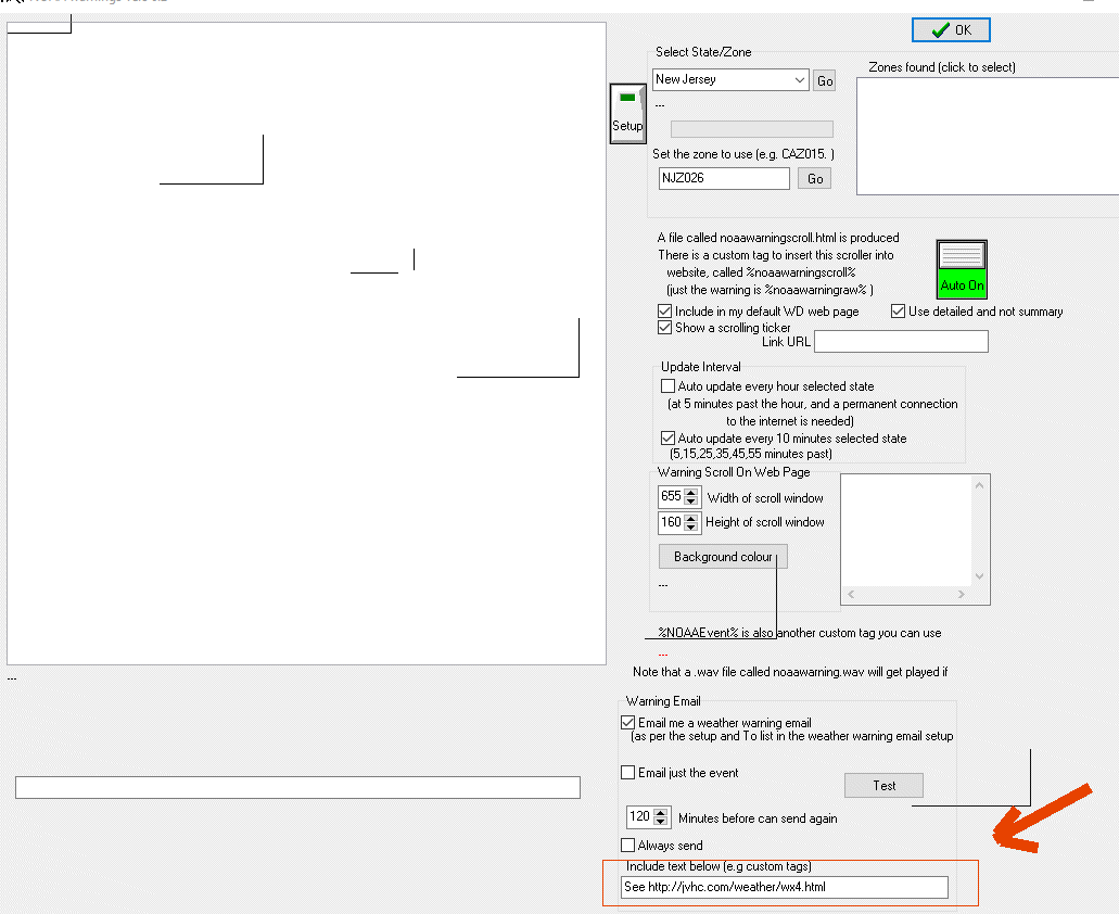
I put it in extra text in the “E-mail warning setup” (extra text to appear) not in “wdxmlwarning.exe” (include text below [e.g. custom tags]),
I tried it in “wdxmlwarning.exe” (include text below [e.g. custom tags]and if I remember right it showed up in the e-mails and i didn’t want that.
no, do not put it in the weather warning setup
that is why its showing up in the normal emails or similar
only put it in the wdxmlwarning.exe program, as explained above
Okay, I’ll try again sorry, the (include text below [e.g. custom tags]) confused me.
Now we need another Alert, LOL. Ill keep you posted. Thanks
That’s the one
Brian,
I put the extra text “See HC Weather”
where you told me -
This is what Twitter sent out -
“HC Weather @jvhc_com 36 minutes ago
Special Weather Statement”
With out “See HC Weather” added.
you would also need to be using the latest WD (weatherdisplay.exe) as well…are you using that?
Ver. 6.2
of weatherdisplay.exe
not wdxmlwarning.exe
10.37S15 The Zip as below
I noticed a newer Zip - Version on 31 July 2016 - 22:39:08
I’ll try that.
where there is a warning /alert active
let me know
so I can test/check here as well
i might have found the issue
download a new .zip update again…
I downloaded new .zip, just received an alert but Twitter only sent the last word of Alert and no extra text.
This is the e-mail:
NOAA XML Warning
NJZ026
Special Weather Statement issued August 01 at 7:26AM EDT until August 01 at 11:00PM EDT by NWS
…
A STRONG THUNDERSTORM WILL AFFECT SOUTHEASTERN MONMOUTH AND NORTHEASTERN OCEAN COUNTIES…
AT 725 AM EDT…
A STRONG THUNDERSTORM WAS OVER BAMBER LAKE…
OR NEAR TOMS RIVER…
MOVING NORTHEAST AT 10 MPH. WIND GUSTS UP TO 30 MPH AND HALF INCH HAIL ARE POSSIBLE WITH THIS STORM.
Special Weather Statement
…A STRONG THUNDERSTORM WILL AFFECT SOUTHEASTERN MONMOUTH AND
NORTHEASTERN OCEAN COUNTIES…
AT 725 AM EDT…A STRONG THUNDERSTORM WAS OVER BAMBER LAKE…OR NEAR
TOMS RIVER…MOVING NORTHEAST AT 10 MPH.
WIND GUSTS UP TO 30 MPH AND HALF INCH HAIL ARE POSSIBLE WITH THIS
STORM.
LOCATIONS IMPACTED INCLUDE…
TOMS RIVER…BEACHWOOD…MANASQUAN…POINT PLEASANT BEACH…
SEASIDE HEIGHTS…MANTOLOKING…PLEASANT PLAINS…
HOLIDAY CITY SOUTH…BRICK TOWNSHIP…LEISURE VILLAGE…
HOLIDAY CITY-BERKELEY…PINE RIDGE AT CRESTWOOD…
DOVER BEACHES SOUTH…LEISURE VILLAGE WEST-PINE LAKE PARK…
LEISURE VILLAGE EAST…BAMBER LAKE…DOVER BEACHES NORTH…
POINT PLEASANT…BRIELLE AND SOUTH TOMS RIVER.
TORRENTIAL RAINFALL IS ALSO OCCURRING WITH THIS STORM…AND MAY CAUSE
LOCALIZED FLOODING. DO NOT DRIVE YOUR VEHICLE THROUGH FLOODED
ROADWAYS.
This is the Tweet:
ROADWAYS.
hummm
when you have a warning/alert next, let me know…
so I can test/check here
Here is one not in my zone but it is active - Hunterdon (NJZ009) New Jersey
fixed it
was missing 1 line of code #-o
use build 16 .zip update, ready now ![]()
:lol: Will do
make sure though to have ticked, email just the event, in the wdxmlwarning.exe too